 |
Fairy Meadows
|
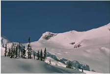 |
"The skiing around Fairy Meadows is truly world famous. You get to choose between short slopes just outside the door or peaks, long tours, and expert level chutes. Of course the powder is unbelievable and you would have to be the unluckiest people in the world not to get some when you go!" (ACC Info)
There really is something for everyone at this hut -
There is some tree skiing to the east below the hut. No glaciers, very little (but not zero) avalanche hazard, and easy access. This is the standard destination for poor visibility days as it can be skied in any conditions. Even on nice days those choosing short ski-for-turns trips nearby use this area along with the "practice slopes". At least one group also reported going down Swan Creek and skiing trees on the other side. However, we have observed large avalanches off of Cycle peak run into some treed sections over in that area so some caution and thought are recommended before checking this out.
The terrain between the hut and Friendship Col is largely unglaciated. The slopes in this 2 km long corridor offer a wide variety of slope angles. Two smaller glaciers do sit in this area. The Shoestring Glacier can be avoided (but apparently offers some good steep skiing for those who choose it, if it is stable) and the upper part of the Echo glacier just below the col is not known to have any open crevasses.
The "practice slopes" right outside the hut offer good short distance yo-yo skiing and were heavily used on our 1999 since we were unable to travel too far from the hut. The end of your run will be just about at the hut door! While these slopes are easily accessible and referred to as "practice slopes" they are potential avalanche terrain and may be unsafe at times of especially high hazard, but this is unusual.
Much of the remaining accessible terrain is glaciated. Any of the longer tours fall into this category. The hut is bounded on the north and the west by the Granite glacier which is very large and very broken up with crevasses in some places. Beyond friendship col is the Gothics glacier which is also reported to be crevassed in sections, although we have never encountered any either in winter or summer.
It is possible to tour to the Great Cairn hut in a long day and in 2002 two of us did this. This is not a trip to be taken lightly - it traverses three glaciated basins, has a very steep descent from Thor Pass which some groups in some conditions may want to rappel (at least in part), and finishes with a descent down a long open and exposed south facing slope from Azimuth ridge late in the day. The proper route off Azimuth Ridge can be a bit difficult to find. The huts are close to the same elevation but the total elevation gain and loss on the tour between them is approximately 5000'. For a strong, well prepared group seeking some adventure this is a rewarding trip. The group should be prepared for the possibility of some short sections involving technical mountaineering skills and should also be prepared to arrive at Great Cairn (quite possibly finishing across refrozen wet slide debris below Azimuth Ridge) by headlamp.
On our 1999 trip the snow was, for the most part, stable and we had only new snow instability to watch out for, especially where a crust was underneath and/or windslabs had been deposited. There were no persistent weak layers of concern buried in the snowpack. Unfortunately we had poor visibility most of the week which prevented the undertaking of any longer tours.
In 2002 we arrived in the midst of a decent snowfall event which was followed by clear sunny skies in early April. While we were cautious the first clear day we found that the air temperatures were cold enough to keep things not only stable but also to maintain powder conditions. Only after several days, towards the end of our trip, did crusts begin to form and afternoon wet slides begin to occur. We skied a number of the classic moderate trips in the area, including Pioneer and Sentinel Peaks, and two of us skied to Great Cairn.
The ACC ran a photography workshop which was guided by ACMG guides in 1999. Here is what their info for that trip said:
Difficulty: Touring, moderate to longer duration and distance with typical winter day packs plus group and individual gear for glacier travel. Fitness and ability strong intermediate to advanced. Terrain moderate to steeper mountainous, heavily glaciated. Ski ascents of moderate difficulty.
While many moderate to long tours are possible and many areas are glaciated it is possible to enjoy a week of less demanding skiing, for the less experienced or less energetic skier. The entire week could easily be spent skiing for turns between the hut and Friendship Col and in the trees below.
The best (and only) skiing book for the area is "Summits and Icefields" by Chic Scott. The maps are 82N/13 (Sullivan River) and 82N/12 (Mt Sir Sandford), available from ITMB. The hut is at 394352 on 82N/13.
|
[Main Fairymeadows 2005 Page] [Organized Trips Page] |
Guiding page
|