 |
Fairy MeadowsApril 9 - 15, 2005Where Is It? |
 |
For anyone who doesn't know where the famous Fairy Meadows Hut is, it's in the northern Selkirk mountains in British Columbia. The Selkirks is one of four ranges which make up the Columbia Mountains which lie west of the Rockies and east of the Coast Range. (The other three are the Caribou, the Monashee, and the Purcell ranges.) The Coast Range gets storms first, fresh off the ocean, and has a maritime snowpack. Lots of snow but few good visibility days until late spring. The Rockies gets the last of the storms and has a continental snowpack, thin with many weak layers in most years. The Columbia Ranges are in between with the best of everything, which is why the majority of the Canadian heli-ski industry operates in these mountains.
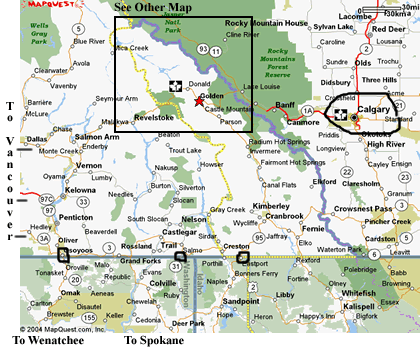
This first map is a large scale overview to place the region in relation to Calgary, Vancouver (off the map to the left), and the Washington/Idaho/Montana borders. The large rectangle is the area shown in the second map below, Calgary is circled, and the border crossings are marked with small squares. There is a red star inside the smaller box marking Golden, which is the meeting place. Most people arrive by car but those that fly usually fly into Calgary and rent a vehicle for the week. Split between several people its not too much. There is bus service as well, although the connection in Calgary from the airport to the bus is not supposed to be too simple. It would also be possible to fly to Spokane and either rent a vehicle there or catch a ride from there with others going up via that route.
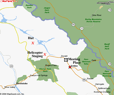
This second map below shows the area marked by a rectangle above. The vast green area on the right is Banff and Jasper national parks in the rockies. The smaller green area is Glacier National Park in the Selkirks (and the even smaller one is Mt Revelstoke Natl Park). While the Rockies are largely park land the Selkirks are mostly Crown-owned non-park lands, outside of Glacier Park. From the meeting point in Golden the helicopter staging area is west along the trans-Canada Highway (Rt 1), just before entering the national park (which prohibits helicopter landings). The hut is a 15-20 minute helicopter flight to the north. Typically it follows the Columbia River north along Kinbasket Lake and the Columbia Reach, which are the larger bodies of water shown. Then they fly up Swan Creek from the low river elevations to the hut which is at the upper edge of treeline. (However, in good weather they may go in more of a straight line up and over the mountains for a truly spectacular flight!)
|
[Main Fairy Meadows 2005 Page] [Organized Trips Page] |
Guiding page
|