 |
Great Cairn Mountaineering TripJuly 24-31, 1999Hike Out Summary |
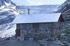
getting started ...
On Thursday we had some discussion about what hour to set out. This is supposed to be a very full day with full packs and I suggested something like 5 a.m. but others felt 7 a.m. or a later time was fine. So we picked something in the middle. I think we were planning on 6 a.m. but by the time we got the hut all closed up and cleaned up from breakfast it was 7. We first had to cross the Silvertip stream. By now we had this down, but it still takes some time to either wade barefoot, change footwear, or splash through but change socks on the far side. Then it was on to
azimuth notch ...
which is above the tip of the Silvertip glacier. The thing which is a bit tricky is that the hut is visible from the notch but the notch can't be distinguished from the hut. It is best to go up along the base of the glacier and then straight uphill into the notch. However, some of our group were determined that it was straight up the Azimuth Peak ridge just behind the hut. I went a bit further towards the glacier, along with a couple others, but we all ended up following the ones out in the lead who went straight up the ridge. At one point Linda took a compass bearing and determined that it was quite a bit to our left. But the group was climbing in a gully at that point and was convinced that the top of it was Azimuth notch. Finally we gained the ridgeline and looked down on the Adamant glacier. We were not in the notch.
There was some discussion about just going down from where we were. The snow rolled over and became quite steep, and there was a bergschrund which probably crossed it although we couldn't see that part due to the steepness. I convinced everyone that we were best off finding the true notch. In retrospect this was a good thing since looking back at the slope later it was clearly quite steep and long. Not everyone in the group had strong snow travel skills. We traversed the ridge into the actual notch, which was a ways along and a good bit lower. This mis-start had cost us about 4 hours plus extra scrambling with heavy packs.
The top of the notch had the remnant of a cornice and was steep so a rappel was necessary. To our right were some old fixed anchors but they were difficult to reach. I quickly slung a large block and set up the rappel with help from Bryan. At least two of the other four rigged their rappel backwards (as if they were going toward the anchor) due to the location where they set it up. But everyone was double checked and set up correctly before actually going down the steep top section. After this one rappel there was just some of a slope left to plunge step down to the flats. Bryan manned the end of the rappel and had people go on down out of reach of rockfall. When I came down I coiled the rope and caught up to everyone on the
adamant glacier ...
which was quite flat where we were to cross it. Up higher it is steep and broken, but the lower flats show no signs of crevasses. Nor was there any sign of the "nefarious swamp" which, according to the climbing guide, forms some years. We chose not to rope up and walked across to the rocks on the other side below the Thor glacier. We stopped for a good break and ate lunch here. Then we started up the
thor glacier basin ...
which was mostly a long, tiring slog up snow of varying steepness. First a relatively steep section to get to the bottom of the Thor glacier, which is a rather small glacier. Then a more gradual climb up around the left side of it. As we approached the base of Thor pass I was beginning to slow down appreciably. A few of the group items I had were distributed to other people. I had grabbed group items which were small but heavy and probably had well in excess of 70 lbs. (This is based on a weight of 68 lbs when we finished, after losing some items and with no lunch foods or water left.) Shortly after this reorganization we arrived at the base of
Thor Pass ...
which looked pretty intimidating from below. The lower part was steep snow with no decent runout if somebody fell and failed to self-arrest. Above the snow was a steep gully filled with loose rocks leading to the pass. Bryan and Vince began the climb while Walter, Linda and I waited. We planned to avoid having part of the group below another part due to the potential of the loose rocks being knocked down. But Walter became impatient and set out as well. He caught up to the other two so all three of them were close together without being below each other. Linda and I continued to wait and watched the others proceed at what seemed a snails pace. When they were near the pass we started up. The snow wasn't as steep as it had looked, although the runout for a fall was not very forgiving. The loose rocks were very tough to ascend. Linda had a particularly hard time, due in part to her pack. The top prevented her from lifting her head and looking uphill. There wasn't anything to belay from even if we had wanted to, but I found good stances and offered my axe as a grip for her in places. This climb into the pass was probably the worst part of the day. When we got to the top we were at the
Gothics glacier ...
which we roped up for. It has a reputation for a few areas of masked crevasses. With the heavy winter and the snow in spring and summer this high elevation section of the glacier was pretty well covered. Even better than it had been in March I think. Walter seemed almost disappointed and I think he still suspects there are no crevasses on this section. But I trust the books that warn of them, based on local knowledge and experience. I'm sure that some years there are plenty of crevasses and a more significant risk than we faced. We crossed the glacier uneventfully (thankfully) and arrived at
Friendship col ...
which is the end of the glacier travel and a short but steep ways above the Fairy Meadows hut. We unroped and descended the Echo glacier, rounded Gog and Magog, and wrapped around the end of the Shoestring glacier. The major hazard through this section was postholing through the snow without warning when you stepped above or close to rocks. A few of us got caught off guard but fortunately there were no sprains or other injuries. We arrived at
Fairy Meadows ...
about dusk. Some of the food which had been planned for dinner had apparently been left at Great Cairn but we made do with what we had and perhaps with a few items found at the hut. Although it was late we did fire up the sauna. We did not need to get too early a start the next morning. There was nobody else at the hut.
It had taken us about 14 hours if I remember correctly, although we had lost 4 hrs with the routefinding misadventures finding Azimuth notch. A very long and very tiring day.
The final hike down Swan Creek ...
The trail down from Fairy Meadows is, in my opinion, just plain ugly. As you first drop from the moraine into the brush the mosquitos are so thick you can't stop. Then come the bogs and swamps. It is an established trail but not a pleasant one. However, it wasn't a particularly long day. We passed a group heading up who seemed to think it was about a four hour trip. (There seems to be a rumour to that effect floating around.) They had not even gotten to the worst sections yet. If I were going into Fairy Meadows with supplies for a week or so I would try to arrange a flight, it would be well worth it. Especially if they were flying in the area anyway and you could avoid the cost of their approach from Golden. From a staging at the base of Swan Creek the flight is short. (But the hike sure would seem long.)
|
[Main Great Cairn 1999 Page] [Main Organized Trips Page] |
Guiding page
|