 |
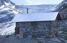
Great Cairn Mountaineering TripJuly 24-31, 1999The Hike Out |
The Hike Out (Pre-Trip Info)
On Friday and Sat July 30-31 we will hike out from the Great Cairn hut. It is possible to fly if everyone, or some sufficient number of people, decide to split the cost. However, this is a significant cost and it cannot be assumed that there will be anyone flying in to dovetail with.
The trip out is a long two days across heavily glaciated terrain. You must be able to do this. If you need to fly out because you are not up to the hike out it could cost up to $1000 if you are the only one. We will do the hike out as a group and there will be sufficient skill and equipment within the group as a whole.
The first day we will travel from Great Cairn to Fairy Meadows. To borrow from the ACC guide to its huts:
This is a big day in the mountains! The route goes over three passes, crosses two major glaciers and covers about 11 km of serious mountain terrain. The Gothics glacier between Friendship col and Thor pass can be very nasty with crevasses, particularly around the south ridge of Sentinel Peak, at any time of the year. Parties making this crossing should be adept at glacier travel and crevasse rescue.
The total elevation gain is 4,100 ft, the net is 500 ft. We climb 2100 ft to Azimuth notch, lose 500 ft to the Adamant glacier, climb 1800 ft to Thor pass, lose 1000 ft on the Gothics glacier, climb 400 ft to Friendship Col, then descend 2200 ft to Fairy Meadows.
The second day is a descent from Fairy Meadows to one of the logging roads along the Columbia reach. This can be difficult to follow and has some exposure above a river down low but is a marked trail.
Anyone wishing to leave on a different schedule, either to climb longer or to get out sooner, will need to plan their own logistics accordingly. Most people will want to have at least two partners with glacier travel skills for the first day. From Fairy Meadows down this is not so important, but the end of the trail is some distance from our staging area for the flight in so you will need to arrange to leave a vehicle in the right place in advance.
Other Routes
There are other land routes to Great Cairn.
The Goat Glacier route involves technical terrain and large crevasses. Descending from the glacier to Gold Creek involves bushwhacking through slide alder in one or more avalanche paths, prime bear habitat. The most direct path reaches the river higher and it is then descended. On the way out the best option would involve just walking through the river in places. The other option comes out lower but involves attempting to link several avalanche paths rather than using one long one. This route takes about 10 hours to get in, going out should probably be about the same.
The Palmer Creek route just follows the creek downhill for 3700 ft. While this sounds simple is rarely used and is only of historical interest. One of the only groups I've even heard of using this in recent years apparently ended up taking four days. Another group apparently was retreived by helicopter when they were unable to complete this route. The north side of the lower drainage burned a few years ago and appears from the air to be relatively open now. But I am unaware of anyone reporting more success via Palmer creek than in the past.
Minaret Col: In May of 1999 Roger Laurilla informed me of a better route out which is not in the books. It would be a one day trip out and would involve far less glacier travel. The elevation gain may be a little less as well but probably not too much so. In March of 2000 I heard that the slopes between Minaret Col and the Gold River had recently been cut, and that groups have done 2 day ascents of Sir Sandford from the logging roads and cutblock below the col. I have not confirmed this and have not spoken to anyone who has actually done it.
|
[Main Great Cairn 1999 Page] [Main Organized Trips Page] |
Guiding page
|