 |
Battle Range MountaineeringJuly 27 - August 4, 2001Traverse to Rogers Pass |
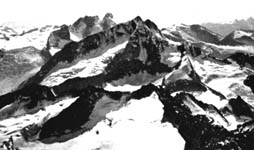
"This high-level route is, in sheer amplitude, without parallel in the Columbia Mountains; moreover, it passes through some of the most spectacular scenery, lofty peaks, and the choicest climbing that the Columbias have to offer
Note - This was preliminary information for anyone interested in forming a team to do the overland traverse from the Battle Range to Rogers Pass. We did not do the traverse on this trip since there was no interest, everybody opted to fly out. The basecamp part of the trip was a week long and the traverse would add up to another week, which may have been a factor for some people.
Time
From the Battle Range it should be 3 long days to Glacier Circle where there is a hut. We will stop for at least one day at the hut, and it may be possible to place some food supplies there in advance. The trip to Glacier Circle can be broken up to allow for climbing and/or resting at least a day.
Skills
This is a mountaineering traverse. It may be of interest to strong backpackers with limited climbing experience and skills, but it will require snow skills including self-arrest, glacier travel skills, and at least one rappel. Interested persons with backpacking experience who lack these basic mountaineering skills should plan on acquiring them prior to the trip. A sound basic mountaineering class will do.
Group Size
We will only do this traverse if there is an adequate group size. Three would be a bare minimum, four or more would be preferred. Anyone participating needs to have enough skill to work as part of a group in any situation such as a crevasse rescue. This requires sound basic skills but not advanced skills or great expertise.
Climbing
There should be opportunities to climb either from Glacier Circle (ideal for the Dawson group with others accessible with longer approaches) or during the traverse depending on how the group decides to plan rest days, etc.
Alternate Routes and Bailing Out
Changing plans once we begin the traverse is extremely difficult. In an emergency, assuming the VHF radio reaches something, we can request a helicopter. This is not included in the trip cost and any person(s) requiring this are fully responsible for the cost. Most of the route is inside Glacier National Park and helicopter landings are prohibited, so this option would only be for a dire emergency in these areas. The park is entered around Sugarloaf Mountain and the route parallels the boundary until passing Mt Wheeler. North of that the boundary is not practical to get to.
After crossing Sugarloaf it is possible to follow the Beaver glacier down to a logging road. Where there may or may not be anyone.
From the Deville Neve it is possible to follow the Bishops Glacier to Bishops Camp. From that camp it is possible to reach Rogers Pass in one long day which is not entirely above treeline like the primary route.
From Glacier Basin it is possible to cross Beaver Creek and follow a trail along the creek to the highway on the east side of Rogers Pass. Or to reach logging roads in the Spillimacheen, where there may or may not be anyone. The Beaver Creek trail is supposedly more of a horse trail with lots of mud and mosquitoes. But if the navigation across the Illecillewaet Neve is looking especially difficult due to weather then this is an option anyway.
Route Summary/Overview
This will begin from Butters Camp, which may take a day to reach from Houston Creek. Unless the helicopter ferries us over there when basecamp is broken up and flown out.
From Butters Camp the route ascends through some timber and alder to cross a saddle on the northeast spur of Mt Butters. It then descend to Butters Lake.
From timberline above Butters Lake a gap in West Beavers long SW Ridge is attained, and through this gap the Battle Glacier is reached. At this point Sugarloaf mountain presents one of the difficulties of the route. The route crosses a divide between West Beaver and Sugarloaf to gain the glacier on the east face of Sugarloaf. This face is steep and exposed to great objective hazard, so the best route goes back to the southeast until the East Ridge can be gained on snow slopes. The east ridge is climbed until it meets the NW Ridge and a descent is possible. So Sugarloaf is essentially climbed just about over the summit. The Grand Glacier is now crossed to approach Grand Mountain. These glaciers south of Grand are supposedly heavily crevassed.
After crossing a col on the east ridge of Grand the Deville neve is attained. It is now about 7 km across the Deville neve to it's northern end and the Deville glacier. The area at the end of this stretch, above the headwall down into Glacier Circle, is another area which is supposed to be heavily crevassed.
To get down into Glacier Circle it is necessary to descend the Deville Chimney through some combination of scrambling on ledges and slabs and rappelling. Once on the floor of the circle the hut is nearby where a well-deserved rest can be had.
The final section is to climb out of Glacier Circle to the North by one of two routes, either climbing up a moraine or scrambling up slabs. This gains the Illecillewaet Neve. After crossing this 8 km or so of undulating snow the route arrives at Perley Rock, and at that point a regularly used trail leads down into Rogers Pass.
Guidebook and maps
"The Columbia Mountains of Canada - Central"; Fox, Laurilla, Putnam, Whipple; American Alpine Club
Westfall River 82K/14
- Covers Battle range
Mount Wheeler 82N/3
- Covers the traverse
Maps are available from ITMB
| [Main Battle Range Trip Page] | Guiding page
|